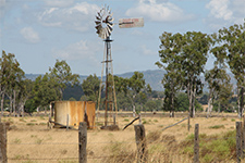
Fitzroy Ridges
Fitzroy Northern Districts to the Ridges and beyond

Local Natural Disaster and Flood information for the
northern area residents of the Rockhampton Region

Local Disaster Information

Emergency contact information
For assistance during a disaster   (only operational during a disaster).
please call the Local Disaster Management Group (LDMG)
Co-ordination Centre on

Police / Fire / Ambulance

State Emergency Service (SES)

Ergon Energy (Life threatening emergencies only)
Ergon Energy - Faults Only

Rockhampton Regional Council (After hours emergencies)


1300 652 659

000

13 25 00

000 or 13 16 70
13 22 96

1300 22 55 77
Police (Emergency)
Rockhampton Police Station (24 hours)
Gracemere Police Station (Mon 9am-5pm, Wed & Thurs 9am-3pm)
Police Link - Policelink
Crime Stoppers - Crime Stoppers Qld
000
4932 3500
4933 1811
131 444
1800 333 000
Queensland Ambulance
Community Contact Centre
1300 369 003
Department of Transport and Main Roads
– Road Conditions
13 19 40
Rockhampton Regional Council Emergency Dashboard gives you access to real time
emergency information all year round, including emergency news, weather warnings,
road closures, power outages and more.
RRC Emergency Dashboard
Local Radio Stations
ABC Radio (837 AM) provides updates for weather advice & warnings.
Radio 4RO (990 AM)

4924 5111
4920 2000 or Studio 4922 7990
Queensland Department of Community Safety –
Disaster Emergency Alerts
Current Warnings and
Emergency Alerts
Flood Warning for the Conners, Isaac, Mackenzie and Fitzroy Rivers and Theresa Creek Flood Warning for the
Fitzroy River
 

Bushfire Season July to November
Bushfire Season Disasters Happen download more infomation...   Bushfire Fact Sheet
Current Bushfire Incidents Map of Current Bushfire Incidents
. Fire Danger Rating National Bushfire Warning System
What do the Fire Danger Rating mean?


Rural Operations Area Office:
Rockhampton 4938 4736
Local Fire Wardens

Cyclone Season November to April
Be Prepared for Disasters Prepare Your Household       Your Emergency Guide   (11.5MB)

Flood Season November to April
Flood information is updated regularly during flood events
Information including predictions about potential flooding PDF files to view or download
Pink Lily and South-East Alton Downs Map of approximate
flood levels that could be expected at 8 metres.
Alton Downs Flood at 8m
Pink Lily and South-East Alton Downs Map of approximate
flood levels that could be expected at 8.5 metres.
Alton Downs Flood at 8.5m
Flood Warning System for the Fitzroy River
Important information during periods of high rainfall and flooding
Flood Warning System Information
for Fitzroy River
Latest River Heights for Neerkol Creek at Stanwell
including reading from the previous seven days
Latest River Heights for Neerkol Creek
at Stanwell
Latest River Heights for Fitzroy River at Rockhampton
including reading from the previous seven days
Latest River Heights for Fitzroy River
at Rockhampton
Latest River Heights for Fitzroy River at Laurel Bank
including reading from the previous seven days
Latest River Heights for Fitzroy River
at Laurel Bank
(Table) Latest River Heights for Fitzroy River at Laurel Bank
including reading from the previous seven days
Table for Latest River Heights
of Fitzroy River at Laurel Bank
Latest River Heights for Fitzroy River at South Yaamba
including reading from the previous seven days
Latest River Heights for Fitzroy River
at South Yaamba
Latest River Heights for Fitzroy River at Wattlebank
including reading from the previous seven days
Latest River Heights for Fitzroy River
at Wattlebank
Latest River Heights for Fitzroy River at The Gap
including reading from the previous seven days
Latest River Heights for Fitzroy River
at The Gap
Latest River Heights for Isaac River at Marlborough Creek
including reading from the previous seven days
Latest River Heights for Isaac River
at Marlborough Creek
Latest River Heights for Fitzroy River at Hanrahans Crossing
including reading from the previous seven days
Latest River Heights Fitzroy River
at Hanrahans Crossing
Latest River Heights for Fitzroy River at Riverslea
including reading from the previous seven days
Latest River Heights for Fitzroy River
at Riverslea
Latest River Heights for for Dawson River at Knebworth
including reading from the previous seven days
Latest River Heights for Dawson River
at Knebworth
Latest River Heights for Mackenzie River at Tartrus
including reading from the previous seven days
Latest River Heights for Mackenzie River
at Tartrus
Latest River Heights for Mackenzie River at Coolmaringa-B
including reading from the previous seven days
Latest River Heights for Mackenzie River
at Coolmaringa-B
Latest River Heights for Mackenzie River at Bedford Weir
including reading from the previous seven days
Latest River Heights for Mackenzie River
at Bedford Weir

Road closure predictions based on the critical flood levels of the 2010/2011 & 2013 Floods Height
Ridgelands Road
Malchi-Nine Mile Road
Capricorn Highway
Rockhampton Airport
Rockhampton Airport
maybe closed at   7.9m
maybe closed at   8.5m
maybe closed at   8.2m
maybe limited at   8.4m
maybe closed at   8.5m

Flood history of the Fitzroy River catchment
.
 
 
During times of flood:
For more flood information call 1300 652 659 or 1300 22 55 77

Tropical cyclone severity categories
(severity scale – Bureau of Meteorology)
Cyclone Categories

For Disaster and more information refer to Emergency Services

Anyone wishing to submit relevant information to be included in this webpage or,
for more information please contact:


  Back to top of page